Lost Mine Trail
Big Bend National Park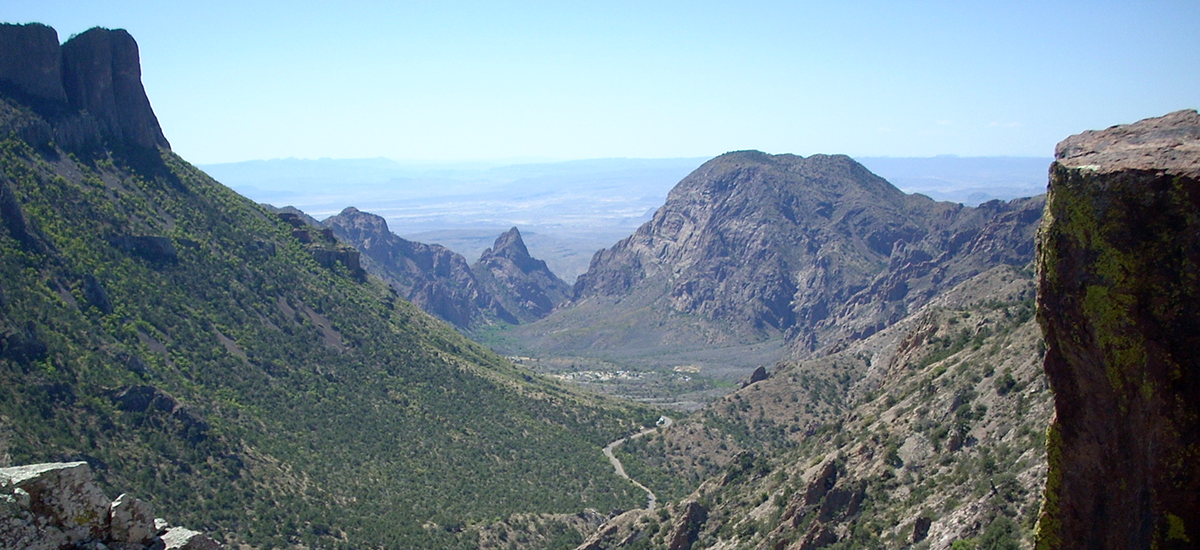
The Lost Mine Trail is one of the most popular in the park. Most hikers in good shape can do the round-trip in three to four hours. For those without the time to hike to the South Rim, this trail is an excellent substitute. People with even less time or energy may elect to hike only the relatively easy first mile of the trail; on a clear day this provides beautiful views of Juniper Canyon and south into Mexico. A self-guiding booklet for this trail can be found in a box at the trailhead; numbered posts along the route match the guide.
The trail ascends gradually through juniper, oak, and pinyon pine forest along the base of Casa Grande Peak. Do not let the steep first 100 feet or so scare you away. At about 1 mile the trail reaches a saddle that looks out over Juniper Canyon and far south into Mexico. From this vantage point you will have views of Casa Grande to the west and Toll Mountain and the Northeast Rim of the Chisos to the south and southwest.
After the saddle, the trail climbs more steeply up a few switchbacks then flattens out temporarily on an open hillside of stipa grass, pinyon pine, an juniper. The trail quickly begins to climb steeply again. Views of Juniper Canyon continue. The trail then narrows, and woods of pinyon pine and oak close in. More switchbacks rapidly add elevation, and good views resume to the south and west. In the midst of the switchbacks you can look west and see the Chisos Basin Campground and the Window.
On the last couple of switchbacks, the trail gets very steep and rocky. Log and rock steps and exposed bedrock int this stretch can be slippery if wet. To most hikers’ relief, the trail abruptly levels off at the top of the ridge. Most of the last 0.5 miles along the exposed ridge is easy. Walk all the way to the end for the best views of Pine Canyon and Sierra Del Carmon in Mexico. On the right, sheer cliffs tumble down into Juniper Canyon, far below. The East Rim of the Chisos Mountains towers over the far side of the broad canyon, and the distinctive pointed summit of Elephant Tusk rises above the desert to the south.
The treasures of the Lost Mine Trail are more spiritual than mineral.